Yellowhammer Survey 2024
This survey aims to gauge how Yellowhammers are doing now compared to previous surveys in 2001 and 2011. We are looking at their breeding distribution and abundance during the forthcoming breeding season.
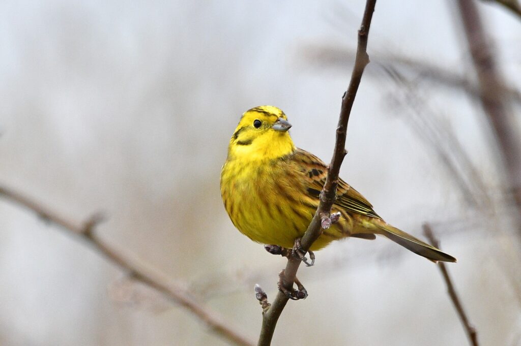
Yellowhammers are iconic, easily identified birds of summer with a classic song. They occupy relatively small territories, typically 60 – 100 m of hedgerow venturing 20 m onto open ground, or a similar sized area of scrub and open ground. Typically the birds favour arable farmland with cereal crops as opposed to intensive grassland farmed for cattle.
The survey is open to the widest range of bird watching interests and expertise – so please get involved in this summer’s Yellowhammer hunt whether that be on a family walk, as an opportunity for young birders or as part of a closer look at your local patch. This is citizen science and we need your help with sightings and surveying between April and July. There are two levels of involvement for this survey as described below so choose what to get involved
Full survey details can also be downloaded at this link
NOTE: The survey has now been completed and results will appear in the CBC Annual Report: Birds & Wildlife in Cumbria 2024.
Level 1. Sightings – if you come across Yellowhammers during the survey period they will most likely be on their breeding territory and since they usually attempt two broods it keeps them busy for four months of summer.
Please help build a map of Yellowhammer distribution (2024) in Cumbria by posting any sightings on the mapping site https://canvis.app/2fnuJe from April through to the end of July.
Level 2. Surveying – OK, so if you can identify a Yellowhammer, have a rough idea of the sort of place they can be found and the size of the territory which they occupy, then please sign up to carry out the survey.
What’s involved?
You will need to carry out a 2 hour walk around a patch sometime in April/May and to revisit the same patch for another 2 hour walk in June/July while making note of Yellowhammer sightings/territories. The survey form can be downloaded here.
How big is a patch?
Well, to enable comparison with previous surveys there is a standard procedure; a patch is a 2 km x 2 km square from Ordnance Survey maps – known as a tetrad. Have a look at the map of tetrads with a history of occupancy from the 2008-11 survey, each symbol represents a tetrad.
Choosing a tetrad
We aim to revisit 10% of the 2008-11 tetrads – see proposed tetrad maps here Contact the survey organisers to sign up for one or more of these as priority tetrads. Survey enthusiasts will cover more than one tetrad and a willingness to cover vacant tetrads will be much appreciated. You can also register for your own tetrad if you have a site of interest to add, but it would still need to be a tetrad survey.
Surveying
Within a tetrad, plot a route which takes in areas of suitable habitat – hedgerows, scrub and cultivated fields and record Yellowhammer territories. Make use of roads, tracks, footpaths and where possible farmland – take care and ensure your own safety, exemplary adherence to Country Code is a must. You cannot cover the whole tetrad so just chose a suitable route. You can vary your route on the second visit, just aim to arrive at a total number of territories recorded on the recording form and submitted to the organisers at the end of July.
Contact the organisers, Mike and Lyn Mills at mike.lyn@talktalk.net
Tel 01946 590616.
Wetland Bird Survey
The Wetland Bird Survey monitors the status of waterbirds in the UK. It is run by the BTO, RSPB, JNCC and WWT and is administered by the BTO. Waterbodies are counted once monthly on or near an appointed date. In Cumbria we have good coverage of sites with most coastal sections and major inland waters counted. However there are vacancies, some of which are of higher priority than others. These are listed in the links below.
The ability to identify waterfowl and a telescope are all that is needed for the survey. Counting on the coast requires more experience as larger numbers of species, more birds and observations at greater distances are involved.
If you would like to help out, please check the BTO map by clicking on ‘Find a vacant site’.
WeBS counter needed for Lake Windermere
August 2023: There is a vacancy for a WeBS counter to cover Lake Windermere. We appreciate that this is a very large water body for one individual to cover. However, as a high priority site we’d be very interested in hearing from anyone who can cover part of the lake.
Please contact Dave Shackleton d.shackleton@btinternet.com for further information.
WeBS counter needed for Border & Calvo Marshes
May 2022: We are looking for a WeBS counter to help out at Border and Calvo Marshes near Abbeytown. These are large marshes with a long walk where a knowledge of the geography of the marshes and the tides is essential to count safely. A few counts can be carried out alongside the existing counter to find the best way to count the section. The area holds good numbers of barnacle geese, wigeon, dunlin, curlew and a host of other waterbirds – a great day’s birding once a month and chance to contribute to an important survey, helping protect the UK’s most important bird sites.
Please contact Dave Blackledge Dave.Blackledge@rspb.org.uk, (coordinator for Inner Solway WeBS counts) for further information.